Today, after a divisive campaign (to say the least) is election day when Americans will elect their next president. The bi-partisan distrust of the two major political parties, namely, the Democrats and Republicans, the power brokers of this nation, raises the question: How long can such a divided and acrimonious United States of America last as one country? Indian history offers a not so optimistic answer.


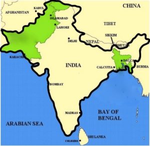
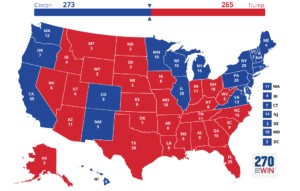
To explain, I shall show two maps – a geographical map of British India at the time of partition (top, left) and the political (“Red and Blue States”) map of America (top, right). What is important is that you see the distribution of the two colors – yellow and green on the map to the left, and red and blue on the map to the right.
Serious religious differences resulted in the breakup of British India into two countries – predominantly Hindu India (shaded yellow) with predominantly Muslim Pakistan (shaded green) on either side of India (East and West Pakistan). East Pakistan became the new country of Bangladesh in 1971.
So, coming back to the political discord in America, blue states (mostly on the two coasts), have more than the necessary 270 electoral votes to elect a president – no red states (the middle part) needed. A rather discomforting thought!
